3D Laser Scanning in Building Construction Comprehensive Guide
[edit] Introducing 3D laser scanning
n recent years, 3D laser scanning has revolutionised the field of building construction. This technology allows for precise and comprehensive documentation of existing structures, aiding in design, construction, and renovation projects. This guide provides a thorough overview of 3D laser scanning for building construction, covering its principles, applications, benefits, equipment, and best practices.
[edit] Principles of 3D laser scanning
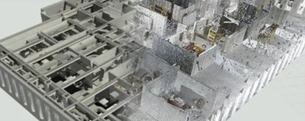
3D laser scanning, also known as terrestrial laser scanning (TLS) or lidar, is a technology that captures the three-dimensional shape of an object or environment using laser light. It is a non-contact, non-destructive technique that can be used to create highly accurate and detailed 3D models. There are two main principles that underpin 3D laser scanning:
[edit] Time of flight (TOF)
Time of flight (TOF): This principle measures the time it takes for a laser pulse to travel from the scanner to the object and back. The distance to the object is then calculated using the speed of light.
[edit] Phase-shift scanning
Phase-shift scanning: This principle measures the phase difference between the emitted laser beam and the reflected beam. The distance to the object is then calculated using the principle of interferometry.
[edit] Accuracy techniques of 3D laser scanning
In addition to these two main principles, 3D laser scanning also uses a number of other techniques to achieve its high level of accuracy, including:
[edit] Triangulation
Triangulation is a technique that uses geometry of the scanner, the target, and the reflected beam to calculate the distance to the object.
[edit] Intensity-based 3D reconstruction
Intensity-based 3D reconstruction is a technique that uses the intensity of the reflected beam to classify different types of surfaces and to identify object boundaries.
[edit] Multi-scan registration
Multi-scan registration is a technique that combines multiple scans of the same object to create a more complete and accurate 3D model.
[edit] Application fields for 3D laser scanning
3D laser scanning is a versatile technology that can be used in a wide range of applications, including:
- Architecture, engineering, and construction (AEC): 3D laser scanning can be used to create as-built models of buildings and structures, to plan and design new projects, and to monitor construction progress.
- Archaeology and cultural heritage: 3D laser scanning can be used to create detailed models of archaeological sites and artifacts, to document and preserve cultural heritage, and to generate virtual reconstructions of ancient structures.
- Forestry and environmental monitoring: 3D laser scanning can be used to map and monitor forests, to assess tree health, and to measure changes in land cover.
- Manufacturing and quality control: 3D laser scanning can be used to inspect manufactured parts for defects, to measure complex shapes, and to create digital twins of products.
- Autonomous vehicles and robotics: 3D laser scanning is used in autonomous vehicles to perceive their surroundings and to detect obstacles. It is also used in robotics to guide robots in tasks such as object manipulation and navigation.
As 3D laser scanning technology continues to develop, it is becoming increasingly affordable, accurate, and versatile. This is leading to the adoption of 3D laser scanning in a growing number of applications, and it is likely to play an increasingly important role in the future.
[edit] 3D Laser Scanning at different building construction project stages
[edit] Building Documentation
At the building documentation stage 3D laser scanning is invaluable for capturing as-built conditions of existing structures, providing a detailed and accurate representation of the building's geometry.
[edit] Design and Planning
At the design and planning stage Architects and designers use 3D laser scanning data to create accurate and detailed models of existing structures, aiding in the design and planning phases of new construction or renovations.
[edit] Construction and Quality Control
In terms of construction and quality control during construction, laser scanning helps ensure that the built structures align with the design plans. It allows for real-time monitoring and quality control, reducing errors and minimising rework.
[edit] Facilities Management
Building owners and facility managers benefit from 3D laser scanning by having comprehensive documentation for maintenance, renovations, and future planning.
[edit] Benefits of 3D Laser Scanning in Building Construction
3D laser scanning, also known as terrestrial laser scanning (TLS) or lidar, is a rapidly growing technology that is transforming the construction industry. This versatile tool offers a wide range of benefits that can improve efficiency, accuracy, and safety throughout the entire project lifecycle. Here are some of the key benefits of using 3D laser scanning in building construction:
[edit] Enhanced Site Analysis and Planning
In terms of enhanced site analysis and planning, 3D laser scanning provides a comprehensive and accurate representation of the existing site conditions, including topography, existing structures, and utilities. This detailed information allows engineers and planners to make informed decisions about site layout, grading, and foundation design, minimising costly errors and rework.
[edit] As-Built Documentation and Quality Control
For as-built documentation and quality control 3D laser scanning can be used to capture the as-built conditions of a building or structure, providing a valuable record for future maintenance and renovations. As-built models can also be used to compare against the original design plans, identifying any deviations or discrepancies that need to be addressed.
[edit] Clash Detection and Coordination
A key benefit is clash detection and coordination as 3D laser scanning can be integrated with BIM (Building Information Modeling) software to detect potential clashes between different building systems, such as mechanical, electrical, and plumbing (MEP) systems. This proactive approach helps to avoid costly rework and delays caused by conflicting installations.
[edit] Safety and Risk Mitigation
3D laser scanning can be used to identify and assess potential safety hazards on a construction site, such as falling debris, unstable structures, or overhead hazards. This information can be used to develop effective safety plans and procedures, reducing the risk of accidents and injuries.
[edit] Progress Monitoring and Documentation
3D laser scanning can be used to track construction progress over time, providing a visual representation of the project's development. This data can be used to identify areas where work is lagging behind schedule and make adjustments to ensure timely completion, as such it can monitor progress and document this.
[edit] Facility Management and Maintenance
Post completion 3D laser scanning can be invaluable for facility management and maintenance needs, it can be used to create detailed models of existing facilities, providing valuable information for maintenance and renovation projects. These models can be used to plan and optimise maintenance tasks, identify potential issues, and track the history of repairs and modifications.
In summary, 3D laser scanning offers a multitude of benefits for building construction, improving efficiency, accuracy, safety, and communication throughout the project lifecycle. As technology advances and costs continue to decrease, 3D laser scanning is poised to become an indispensable tool for the construction industry.
[edit] Elements of and equipment for 3D Laser Scanning
The basic elements and equipment required for 3D laser scanning includes:
[edit] Laser scanner
The laser scanner is the heart of the system and emits a beam of laser light that measures the distance to objects in its field of view.
[edit] Tripod
The tripod is used to mount the laser scanner and stabilise it during scanning operations.
[edit] Target
Targets are reflective objects that are placed around the scanning area to help the laser scanner register and align the scans.
[edit] Data recorder
The data recorder stores the raw point cloud data captured by the laser scanner.
[edit] Processing software
The processing software is used to convert the raw point cloud data into a usable 3D model.
[edit] Optional accessories
In addition to this basic equipment, there are a number of optional accessories that can be used to enhance the capabilities of the system. These accessories include:
- High-resolution camera: A high-resolution camera can be used to capture images of the scanning area, which can be used to texture the 3D model.
- GPS receiver: A GPS receiver can be used to georeference the 3D model, which allows it to be accurately placed in real-world coordinates.
- Scanner controller: A scanner controller is a handheld device that allows the operator to control the laser scanner and view the scan data in real time.
The specific equipment required for a particular project will vary depending on the size and complexity of the project, as well as the desired level of accuracy.
[edit] Best practice for 3D laser scanning
Here are some of the best practices for 3D laser scanning:
[edit] Planning and preparation
- Define the project scope and objectives: Clearly outline the purpose of the 3D laser scanning and the specific deliverables required.
- Understand the site conditions: Familiarize yourself with the layout, potential obstacles, and safety hazards of the scanning area.
- Obtain necessary permits and approvals: Secure any required permits or permissions for accessing the scanning site.
[edit] Equipment setup and calibration
- Properly mount the laser scanner: Use a stable tripod and ensure the scanner is level and aligned.
- Position targets strategically: Place targets throughout the scanning area to aid in scan registration and alignment.
- Calibrate the laser scanner: Follow the manufacturer's instructions to calibrate the scanner for optimal accuracy.
[edit] Scan data acquisition
- Establish scan positions: Plan the scan locations to achieve complete coverage of the target area.
- Capture overlapping scans: Overlap adjacent scans to ensure seamless integration and reduce data gaps.
- Maintain consistent scan settings: Use consistent scanning parameters throughout the project for consistent data quality.
[edit] Data processing and registration
- Pre-process the point cloud data: Filter out noise and outliers, and classify points into relevant categories.
- Register the scans: Align individual scans using targets or other reference points to create a unified 3D model.
- Post-process the 3D model: Smooth out surfaces, fill in gaps, and enhance details for a refined representation.
[edit] Quality assurance and control
- Validate scan accuracy: Compare the 3D model to known dimensions or reference data to verify its accuracy.
- Check for data completeness: Ensure that the 3D model captures all relevant features and details of the scanned environment.
- Address data errors: Identify and correct any errors or inconsistencies in the 3D model.
[edit] Data management and delivery
- Organise and store the data: Implement a structured data management system for easy retrieval and organisation.
- Choose appropriate file formats: Select suitable file formats for compatibility with various software and applications.
- Deliver the data securely: Employ secure methods for sharing and transferring the 3D model and associated data.
[edit] Conclusion
3D laser scanning has become an indispensable tool in the construction industry, providing unparalleled accuracy and efficiency. As technology continues to advance, integrating 3D laser scanning into building construction processes will become even more commonplace, further streamlining workflows and improving project outcomes.
[edit] Related articles on Designing Buildings
- 3D city model.
- 3D printer.
- 6 Uses of 3D Laser Scanning in Construction Project.
- BIM for heritage asset management.
- Building survey.
- Construction drones.
- Drones as a Service DaaS.
- Geophysical survey.
- Ground control point GCP.
- How can drones transform construction processes.
- Impulse radar.
- Interview with David Southam about laser scanning in construction.
- Laser.
- Laser scanning for building design and construction.
- Pre-construction information.
- Radar.
- Scan to BIM: Enhancing Building Information Modeling with 3D Laser Scanning.
- Site information.
- Site surveys.
- Surveying instruments.
- Surveyor.
- Technical due diligence.
- Uses of drones in construction.
- Vendor survey.
- What does BIM have in store for the construction industry?.
Featured articles and news
Amendment to the GB Energy Bill welcomed by ECA
Move prevents nationally-owned energy company from investing in solar panels produced by modern slavery.
Gregor Harvie argues that AI is state-sanctioned theft of IP.
Heat pumps, vehicle chargers and heating appliances must be sold with smart functionality.
Experimental AI housing target help for councils
Experimental AI could help councils meet housing targets by digitising records.
New-style degrees set for reformed ARB accreditation
Following the ARB Tomorrow's Architects competency outcomes for Architects.
BSRIA Occupant Wellbeing survey BOW
Occupant satisfaction and wellbeing tool inc. physical environment, indoor facilities, functionality and accessibility.
Preserving, waterproofing and decorating buildings.
Many resources for visitors aswell as new features for members.
Using technology to empower communities
The Community data platform; capturing the DNA of a place and fostering participation, for better design.
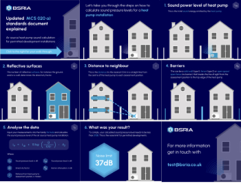
Heat pump and wind turbine sound calculations for PDRs
MCS publish updated sound calculation standards for permitted development installations.
Homes England creates largest housing-led site in the North
Successful, 34 hectare land acquisition with the residential allocation now completed.
Scottish apprenticeship training proposals
General support although better accountability and transparency is sought.
The history of building regulations
A story of belated action in response to crisis.
Moisture, fire safety and emerging trends in living walls
How wet is your wall?
Current policy explained and newly published consultation by the UK and Welsh Governments.
British architecture 1919–39. Book review.
Conservation of listed prefabs in Moseley.
Energy industry calls for urgent reform.


